
Aerial Photography County Coverage: 1967 - 1971
The following graphic indicates the air photo coverage (shaded in orange) held in the Map Collection for 1967 to 1971. Specific county coverage details, including scale where available, are provided as well.
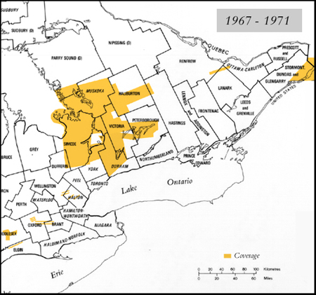
Details
- DURHAM 1:15,840 - 1971
- ELGIN 1:27,000 - 1971
- HALIBURTON 1:15,840 - 1969
- LANARK (some of Renfrew) 1:15,840 - 1969
- MIDDLESEX 1:25,600 - 1970
- MIDDLESEX 1:27,000 - 1971
- MUSKOKA 1:15,840 - 1969
- MUSKOKA 1:15,840 - 1971
- PARRY SOUND 1:17,000 - 1969
- PETERBOROUGH 1:15,840 - 1971
- OXFORD (Pittock Reservoir) 1:13,000 - 1967
- OXFORD (Woodstock-Brant) 1:12,000 - 1967
- SIMCOE 1:16,000 - 1969
- SIMCOE 1:15,840 - 1971
- SIMCOE (North) 1:15,840 - 1971
- STORMONT 1:24,000 - 1969
- VICTORIA 1:15,840 - 1971
- VICTORIA 1:16,000 - 1969
- WELLINGTON (Guelph-Acton) 1:12,000 - 1971
- YORK 1:15,840 - 1971