
Ontario Fundamental Dataset
The topographic vector GIS Ontario Fundamental Dataset covers all of Ontario at a scale of 1:10,000 for Southern Ontario and 1:20,000 for Northern Ontario and are organized and divided by either MNR Districts or MNR Regions. This data resource replaces the Ontario Base Map (OBM) data and is maintained in the Natural Resources and Values Information System (NRVIS).
Coordinate system: Geographic (Lat. and Long.) - NAD 83
Source format: ESRI Shapefiles (ArcGIS/ArcView)
Updated: Various Years, as recent as 2013
Available Themes / Layers (Vector Format)
- Airports
- Buildings (Polygons and Points)
- Concessions
- Conservation Authority Areas
- Conservation Reserves
- Contours
- Crown Game Preserves
- Crown Leased Land
- Drainage Lines
- Drainage Points
- Geographic Townships
- Land Ownership
- Lots
- Mine Sites
- Miscellaneous Lines (ex. Cliffs, Dykes, Fences, etc.)
- Miscellaneous Points (ex. Control Monuments)
- MNR Districts
- MNR Regions
- Municipal Boundaries (Lower Tier and Upper Tier)
- Municipal Parks
- National Parks
- National Wildlife Areas
- NGO Nature Reserves
- OBM DTMs
- OBM Index
- Pits or Quarries
- Provincial Parks
- Railways
- Roads
- Spot Height Points
- Tanks
- Towers
- Trails
- Transport Lines and Points
- Unorganized Areas
- Utility Lines
- Water Edges
- Water Structures
- Waterbodies
- Wetland Units
- Wooded Areas
Restrictions on Access
This resource is available to University of Western Ontario students, faculty and staff for academic, research or personal reasons. Patrons will be required to present a valid UWO ID card and sign a release form when requesting the data. Data must be requested in person at the Map and Data Centre Reference desk.
Non-UWO community members can access the data over the internet via the The Geography Network. The Fundamental data is free for download in various file formats including ESRI Shapefiles, AutoCad DWG/DXF, etc. Simply zoom to the area of interest, choose your visible layers, and click the button to download the data. Interactive mapping and download capabilities are powered by ArcIMS.
Older Ontario Base Map (OBM) GIS data tiles can be acquired by UWO patrons with Social Science Network access by downloading directly from the L:\ Drive. Using ArcMap, open the ArcMap document file titled “OBMindex” within the OBMindex2 folder. Navigate to the area of interest and click on the appropriate tile with the Hyperlink tool to activate the download.
Data Manipulation / Usage
The Map and Data Centre has 2 GIS workstations equipped with ArcGIS 10.0 and other software to explore/manipulate the data. UWO users may also copy requested resources to a data storage device (ex. USB flash drive, CD-R) for research or teaching use outside of the library. The Ontario Ministry of Natural Resources should be cited in any maps or graphics generated.
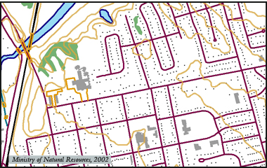
Sample View of the Data
Built Up Urban area Fundamental Dataset sample - Woodstock, Ontario
Sample Citation
Ontario Fundamental Dataset [computer file]. Peterborough: Ontario Ministry of Natural Resources, 2002.