City of Hamilton Orthoimagery
2009 City of Hamilton Orthoimagery
The 2009 Colour Orthoimagery of the City of Hamilton is in 3 compressed aerial photo MrSID mosaic files at a spatial resolution of 20cm. The file sizes range from approximately 1.6gb to 2.0gb.
Coordinate system: UTM - NAD'83, 6° projection, Zone 17.
Aerial photography date: Spring 2009
Ground pixel resolution: 20cm
Source format: 'SID' World.
'SID' created: 2009.
Library Call Number: GD.CA.10 (Regional)
Restrictions on Access / Use
This resource is available to University of Western students, faculty and staff for academic, research or personal reasons. The City of Hamilton should be cited in any maps or graphics generated. Patrons will be required to sign a release form when requesting the data. Data must be requested in person at the Map and Data Centre Reference desk.
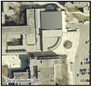
Sample View of the Data
McMaster University Student Centre Entrance - Hamilton, Ontario
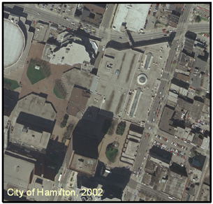
2002 City of Hamilton Orthoimagery
The 2002 Colour Orthoimagery of the City of Hamilton is in 9 compressed aerial photo MrSID mosaic files at a spatial resolution of 20cm with a 20:1 compression ratio. The file sizes range from approximately 431.1mb to 600.7mb. An index has been provided by the City of Hamilton, GIS Services.
Coordinate system: UTM - NAD'83, 6° projection, Zone 17.
Aerial photography date: Spring 2002
Ground pixel resolution: 20cm
Source format: 'SID' World.
'SID' created: 2002.
Restrictions on Access / Use
This resource is available to University of Western students, faculty and staff for academic, research or personal reasons. The City of Hamilton should be cited in any maps or graphics generated. Patrons will be required to sign a release form when requesting the data. Data must be requested in person at the Map and Data Centre Reference desk.
Sample View of the Data
Jackson Square - Hamilton, Ontario - 1:10,000
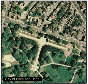
1999 City of Hamilton Orthoimagery
The 1999 Colour Orthoimagery of the City of Hamilton is in 8 compressed aerial photo MrSID mosaic files at a spatial resolution of 12.5cm. The file sizes range from approximately 364.2mb to 541.1mb. An index has been provided by the City of Hamilton, GIS Services.
Coordinate system: UTM - NAD'83, 6° projection, Zone 17.
Aerial photography date: 1999
Ground pixel resolution: 12.5cm
Source format: 'SID' World.
'SID' created: 2002.
Restrictions on Access / Use
This resource is available to University of Western students, faculty and staff for academic, research or personal reasons. The City of Hamilton should be cited in any maps or graphics generated. Patrons will be required to sign a release form when requesting the data. Data must be requested in person at the Map and Data Centre Reference desk.
Sample View of the Data
Gage Park, North Entrance - Hamilton, Ontario - 1:10,000