
Nunavut Geoscience Sampler GIS Data
The 2004 Nunavut Geoscience Sampler contains a large amount of vector GIS data including geologic, and management information for the Territory of Nunavut. The file size of the entire vector dataset is approximately 220mb.
Coordinate system: NAD 83 - Lambert Conformal Conic
Source format: ESRI Shapefiles (ArcGIS/ArcView)
Released: October 2004
Library Call Number: GD.CA.31 (Provincial)
Available Themes / Layers
Bedrock Geology (various coverage), Boundaries, Faults, Geology(1:5million), Heritage Rivers, Inuit Owned Lands, Migratory Bird Sanctuaries, Mineral Tenure, National Parks, Oil and Gas Rights, Surficial Geology (various coverage), Territorial Parks, Towns, Water (Lakes and Rivers), and Wildlife Preserves and Sanctuaries.
Restrictions on Access
This resource is available to University of Western Ontario students, faculty and staff for academic, research or personal reasons. Patrons will be required to present a valid UWO ID card and sign a release form when requesting the data. Data must be requested in person at the Map and Data Centre Reference desk.
Data Manipulation / Usage
The Map and Data Centre has 2 GIS workstations equipped with ArcGIS 10.0 and other software to explore/manipulate the data. UWO users may also copy requested resources to a data storage device (ex. USB flash drive, CD-R) for research or teaching use outside of the library. Canada-Nunavut Geoscience should be cited in any maps or graphics generated.
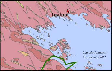
Sample View of the Data
Surficial Geology in the area of Iqaluit - South Baffin Island, Nunavut
Sample Citation
Nunavut Geoscience Sampler [computer file]. Iqaluit, Nunavut : Canada-Nunavut Geoscience Office, 2004.