
Ottawa Region Vector Data
2003 Ottawa Topographic Mapping
The 2003 Ottawa Topographic Mapping dataset contains 1:2000 scale vector data for the urban area of the City of Ottawa and 1:10,000 scale vector road network and address point files covering the entire Ottawa Region. The file size of the entire vector dataset is approximately 3.27gb.
Coordinate system: Modified Transverse Mercator (MTM) - NAD 83, Zone 9
Source format: ESRI Shapefiles (ArcGIS/ArcView)
Updated: 2003
Available Themes / Layers
1:2,000 Scale Directory
- Accessway
- All Else (contains many themes)
- Bridge
- Building
- Contours
- Driveway
- Forest
- Laneway
- Miscellaneous (contains many themes)
- Parking Lot - Paved
- Parking Lot - Unpaved
- Pathway
- Road Centre Line
- Road Shapes
- Runway
- Sidewalk
- Tree Drip Line
- Vegetation
- Water
- Wood Outline
1:10,000 Scale Directory
- Address Point - Main
- Address Point - Subordinate
- Road Segment - Operational
- Road Segment - Proposed
Restrictions on Access
This resource is available to University of Western Ontario students, faculty and staff for academic, research or personal reasons. Patrons will be required to present a valid UWO ID card and sign a release form when requesting the data. Data must be requested in person at the Map and Data Centre Reference desk.
Data Manipulation / Usage
The Map and Data Centre has 2 GIS workstations equipped with ArcGIS 10.0 and other software to explore/manipulate the data. UWO users may also copy requested resources to a data storage device (ex. USB flash drive, CD-R) for research or teaching use outside of the library. The City of Ottawa should be cited in any maps or graphics generated.
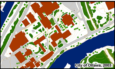
Sample View of the Data
Carleton University Campusr - Ottawa, Ontario
Sample Citation
Ottawa 1:2,000 Scale Topographic Data [computer file]. Ottawa: City of Ottawa, 2003.
1998 National Capital Commission Vector Data
The 1998 National Capital Commission vector GIS dataset contains topographic and information for the National Capital Region (includes the City of Ottawa and Gatineau) based on a scale of 1:25,000. The file size of the entire vector dataset is approximately 77mb.
Coordinate system: Modified Transverse Mercator (MTM) - NAD 83, Zone 9
Source format: ESRI Shapefiles (ArcGIS/ArcView)
Updated: 1998
Library Call Number: GD.CA.11.1 (Regional)
Available Themes / Layers
Airports, Boundaries (Cities, 1973 Game Boundary, Gatineau Park, 1961 Green Belt, National Capital Region), Buildings (Large), Contours (5m interval), Hydro Lines, Major Roads, Major Water, Municipal Drains, Picnic Areas, Railroads, Recreational Paths and Trails, Roads, Site Camping Areas, Tile Drained Fields, Towns, Vegetation, and Water (Lines and Polygons).
Restrictions on Access
This resource is available to University of Western Ontario students, faculty and staff for academic, research or personal reasons. Patrons will be required to present a valid UWO ID card and sign a release form when requesting the data. Data must be requested in person at the Map and Data Centre Reference desk.
Data Manipulation / Usage
The Map and Data Centre has 5 GIS workstations equipped with ArcGIS 9.x and other software to explore/manipulate the data. UWO users may also copy requested resources to a data storage device (ex. USB flash drive, CD-R) for research or teaching use outside of the library. The National Capital Commission should be cited in any maps or graphics generated.
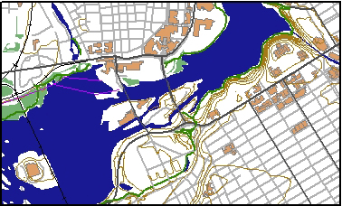
Sample View of the Data
A Portion of the Ottawa River - Ottawa, Ontario
Sample Citation
National Capital Region GIS Vector Data [computer file]. Ottawa: National Capital Commission, 1998.