
Aerial Photography County Coverage: 1962 - 1966
The following graphic indicates the air photo coverage (shaded in orange) held in the Map Collection for 1962 to 1966. Specific county coverage details, including scale where available, are provided as well.
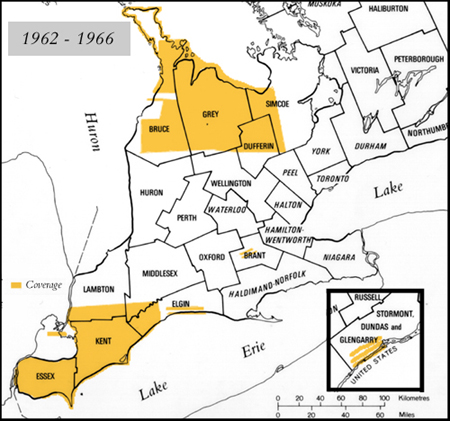
Details
- BRANT 1:17,000 - 1964
- BRUCE (North) 1:15,840 - 1966
- BRUCE (South) 1:15,840 - 1966
- BRUCE/GREY (Shoreline) 1:15,840 - 1965
- DUFFERIN 1:15,840 - 1966
- ELGIN 1:17,000 - 1963
- ELGIN 1:17,000 - 1966
- ESSEX 1:15,840 - 1962
- GREY (Georgian Bay shore) 1:12,000 - 1964
- GREY (North) 1:15,840 - 1966
- GREY (South) 1:15,840 - 1966
- LAMBTON 1:15,840 - 1962
- SIMCOE 1:15,840 - 1966
- STORMONT 1:25,000 - 1964
- WELLINGTON 1:15,000 - 1966